

Photo credit IG @fcosc22

Here are all the important things to know about McCredie Hot Springs:
- Location: in the Willamette National Forest, off of the Willamette Pass Highway / Oregon Route 58 (near Blue Pool Campground)
- GPS coordinates: 43.7040120, -122.2872629
- Nearest town: Oakridge, which is 10 miles west of the hot springs
- Access: easy, .3-mile hike
- Time of year: open all year long
- Cost: Free, no permit required
- Toilets: no toilets at the pools themselves, but there is a pit toilet a short drive away at the day-use parking lot
- Day use only (no camping overnight)
- Camping: no on-site camping allowed; Blue Pools campground is .05 miles away and is nearest to the hot springs (closed in the winter), there are many more campgrounds along the Willamette Highway.
- Type of hot spring: natural/undeveloped, rock walls have been formed to keep the water in, but they are kept mostly in their natural form
- Number of pools: 2 – 4; This can change depending on the time of year and water levels. During our visit (in February 2019), there were 2 pools with hot water, but we’ve heard there used to be 3 or 4 pools.
- Water clarity: somewhat murky
- Temperature (at source): 130ºF
- Depth: quite shallow, maybe 2 feet at its deepest
- Odor: we didn’t notice much of a sulfuric smell, and none of my silver jewelry tarnished as it has in hot springs with high sulfuric levels
- Clothing: optional
(thanks to gowanderwild.com for these great stats and the fantastic directions you’ll find below)
How to get to McCredie Hot Springs
[Drive + an easy .3-mile / 10-minute hike (one way)]
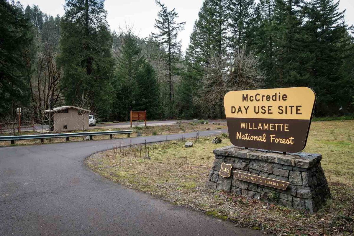
On Google Maps, the rest stop labeled as the McCredie Day Use Parking Lot is not your final destination. I repeat this is NOT where you’ll be parking.
They do have a picnic table and a pit toilet (which was pretty unkempt when we were there, but it was February so I’d imagine it’s better looked-after in the summer months). So if you need to use either of those facilities, by all means, make a stop.
The main hot springs are located on the south side of the river (opposite of the highway).
Directions to McCredie Hot Springs
- Distance from Eugene: 53 miles, 1 hour
- Distance from Bend: 87 miles, 1 hour 35 minutes
- Distance from Salem: 114 miles, 2 hours
- Distance from Portland: 157 miles, 2 hours 30 minutes
- Distance from Oakridge: 10 miles, 13 minutes
Good to know: The Willamette Highway leading up to McCredie Hot Springs has many twists and turns, and lots of large semi-trucks use this route. Be careful and keep your eyes on the road.
Coming from the West (Eugene)
[You are driving eastbound on Highway 58 / Willamette Highway]
- Drive 10 miles east of Oakridge.
- You will see the McCredie Hot Springs Day Use Parking Lot on the right-hand side of the road.
- Stop here if you need to use the toilet, otherwise keep driving .5 miles.
- When you see the sign for Shady Gap Road and/or Wicopee Fields, turn right.
- Follow Shady Gap Road over a one-lane bridge, which crosses the Salt Creek River.
- Continue on this road as it curves to the right (don’t take a left turn after the bridge). You will now be on NF-5875 road (National Forest Service Road).
- The road widens and continues uphill, curving left.
- Stop and park your car in the wide section of the road (before the uphill).
- You will see the trailhead to your right, marked with a sign that explains this is day-use only.
Continue reading below to see more information on this hike.
Coming from the East (Bend, etc.)
[You are driving westbound on Highway 58 / Willamette Highway]
- After passing the Willamette Pass Ski Resort, continue driving for 17 miles (about 20 minutes).
- Pay careful attention to the road signs, as the sign you’re looking for is small and not obvious. When you see the sign for Shady Gap Road and/or Wicopee Fields, turn right.
- If you see the McCredie Hot Springs Day Use Parking Lot on the left-hand side of the road, so you have driven too far and will need to turn around and drive .5 miles until you see the sign for Shady Gap Road.
- If you need to use the restroom, drive here first then turn around.
- Follow Shady Gap Road over a one-lane bridge, which crosses the Salt Creek River.
- Continue on this road as it curves to the right (don’t take a left turn after the bridge).
- The road widens and continues uphill, curving left.
- Stop and park your car in the wide section of the road (before the uphill).
- You will see the trailhead to your right, marked with a sign that explains this is day-use only.
The Hike to McCredie Hot Springs
Now that you’ve parked in the correct spot (yay!), you’ve got a short way to hike in. Don’t worry, it’s very easy!
- Clothing is optional. If this is going to make you uncomfortable, you may not enjoy this experience.
- The water is somewhat murky, as the bottom is a mixture of sand and dirt. We wouldn’t recommend wearing anything that will be ruined if it gets a little dirty.
- Be careful, as there are some very hot pockets in the sand where the spring water seeps through. Take a moment to scope out a spot that isn’t too hot.
- There is not a toilet facility at the pools, contrary to what some of the other articles online make it sound like. The pit toilet they’re speaking of is located in the day-use parking lot, which as we’ve already explained, is on the other side of the river from the hot springs and is not where you should park. If you need to change into a bathing suit or use the bathroom, we’d recommend stopping at the day-use parking lot first before proceeding to the hot springs itself.